Lightning Mapping Observations in Central Oklahoma
Paul R. Krehbiel, Ronald J. Thomas, William Rison,
Timothy Hamlin, Jeremiah Harlin, and Michael Davis
Langmuir Laboratory for Atmospheric Research, Geophysical Research
Center,
New Mexico Institute of Mining and Technology, Socorro, New Mexico
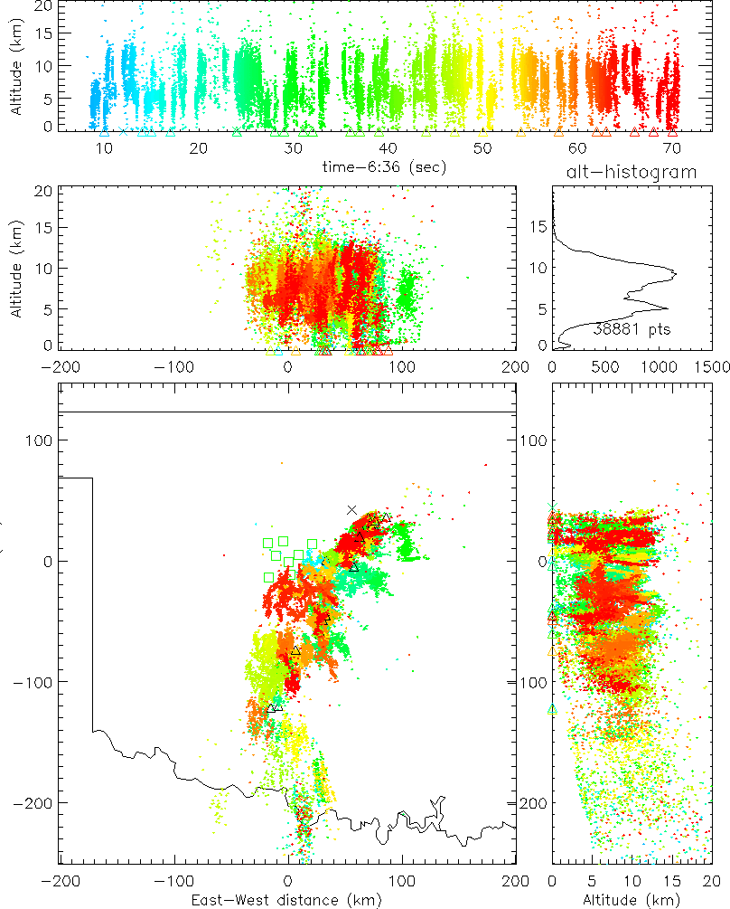
Great Plains storms are well known for their ability to produce severe weather. They are also prodigious producers of lightning. Just how prodigious has been graphically illustrated by recent observations in central Oklahoma with a new GPS-based lightning mapping system. The observations are useful not only for studying storm electrification but have also been found to provide a valuable indicator of storm structure and intensity.
Lightning can be mapped in three spatial dimensions by measuring the arrival times of VHF radiation produced by individual discharges as they progress through a storm. The availability of accurate, low-cost GPS receivers has made it relatively easy to obtain measurements that give high quality pictures of the total lightning activity over a large geographical area. Figure 1a shows an example of such observations from a line of thunderstorms that moved over central Oklahoma on the night of June 10-11, 1998. Ten mapping stations were deployed over a county-wide area northwest of Oklahoma City and detected lightning from the storm system as far south as the Oklahoma-Texas border. The figure presents one minute of activity and shows that major lightning discharges occurred about once per second at different locations along the 200-300 km extent of the storm, out to the maximum range of the mapping system.
Figure 1b shows a slightly expanded view of five minutes of observations from the storm. Instead of overlaying events on top of one another, as in Figure 1a, the figure now shows the density of lightning radiation events. The lightning activity is seen to be most concentrated in a few locations that correspond to the main convective cells of the storm. The temporal sequence of such observations shows the development and motion of the cells and of the storm as a whole (see http://ibis.nmt.edu/nmt_lms).
System Operation
The lightning mapping system has been developed at New Mexico Tech under an Academic Research Infrastructure grant from the National Science Foundation, and is patterned after the Lightning Detection and Ranging (LDAR) system developed at the NASA Kennedy Space Center [Maier et al., 1995]. The system operates by detecting radiation from lightning discharges in an unused VHF television channel, in this case Channel 3 (60-66 MHz). Rather than telemeter high-bandwidth data to a central site to measure the time-of-arrival values, however, the system takes advantage of currently available GPS technology to measure the arrival times independently at each remote location. In particular, the arrival times are determined with 50 ns time resolution by phase-locking a 20 MHz digitizer to the 1 pulse per second output of a GPS receiver at each station [Rison et al., 1999]. The time of the peak radiation event is recorded in every 100 microsecond window that the signal exceeds a noise threshold.
The data in this article are from the initial operation of the system in Oklahoma during June, 1998. The results were obtained by post-processing data recorded locally at each measurement site. The observations were analysed using an automated procedure which identifies sets of arrival times that potentially correspond to each other and processes the arrival times to determine the source location and goodness of fit value. The statistics of the measurement errors indicate overall timing uncertainties of 40-50 ns rms, corresponding to 50 to 100 m best-case location errors over the network. The location uncertainties increase with distance from the array, becoming radial at large distances, where the locations are primarily two-dimensional. The signal propagation is line-of-sight, so that distant sources below the local horizon are not detected by the network. This causes the minimum source altitude to increase with range, as seen in Figure 1.
In effect, the mapping system constitutes a highly accurate space-time filter that enables correlated events to be extracted from the complex data stream and uncorrelated events to be rejected. The result is that one is able to sort out simultaneous activity both from a given lightning discharge and from multiple discharges in different locations. This ability is crucial in large storm systems, where the lightning activity is widespread and often nearly continuous. It was not unusual in Oklahoma for the system to be triggered during 90% of the 100-microsecond data windows (9000 times per second) during active storms. 500 to 1000 events per second were typically located during such activity.
A Horizontally Extensive Discharge
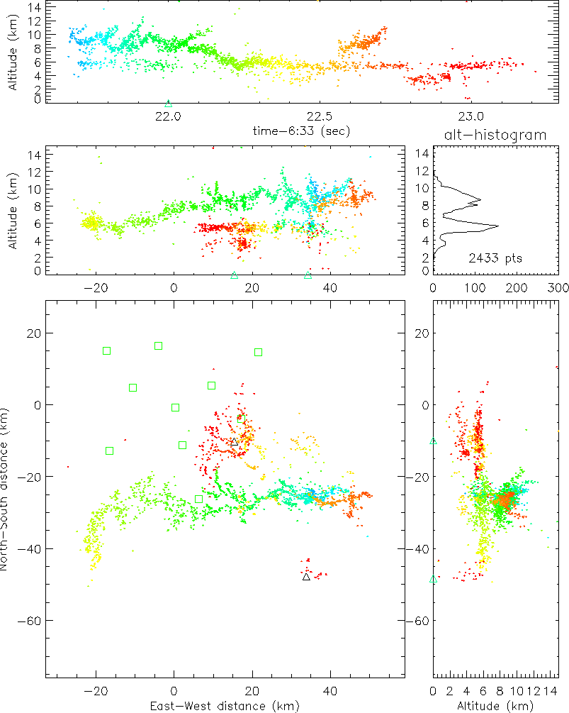
Figure 2 shows observations of a horizontally extensive lightning discharge from the storm of Figure 1. The discharge occurred over the southern edge of the measurement network and had an overall extent of 75 km. It discharged three charge levels in the storm; from other studies, the middle and upper levels correspond to the main negative and upper positive charge regions of the storm [Shao and Krehbiel, 1996]. The flash began as an intracloud discharge between these two levels. During this time the upper level channel propagated more than 50 km to the west and decreased in altitude, indicating that the upper positive charge region similarly decreased in altitude. Subsequent breakdown in the negative charge level continued the discharge to the north, where it produced a negative-polarity stroke to ground. The time and location of the ground stroke is indicated by data from the National Lightning Detection Network [Cummins et al., 1998] and is denoted by the small triangle. In the process of going to ground the breakdown appeared to discharge a region of lower positive charge, indicated by a third level of radiation sources between 3 and 4 km altitude. A considerably simpler cloud-to-ground discharge occurred in a separate part of the storm to the south.
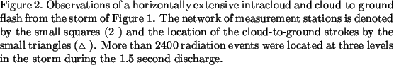
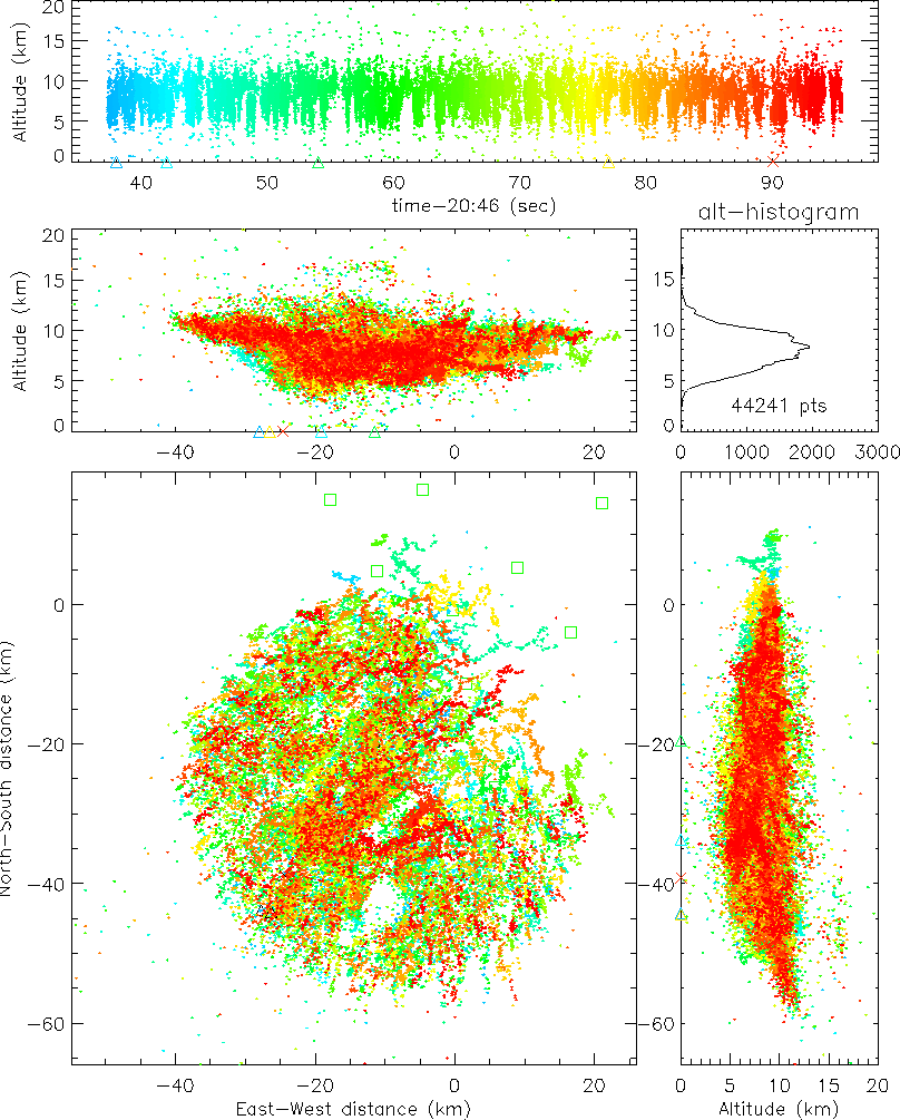
Supercell Lightning
Figure 3 shows one minute of lightning in a large `supercell' storm,
one of several that occurred over central Oklahoma on the afternoon
of June 8, 1998. The storm was a single entity about 60 km in diameter
that produced large hail and torrential rains, but no tornadic activity.
In contrast with the observations of Figure 1, where the lightning at a
given location consisted of isolated events having a relatively well-defined
structure, lightning in the supercell was essentially continuous and had an
amorphous structure. The cumulative effect of the lightning was to fill a
saucer-shaped volume over the 60 km diameter of the storm, up to a height of
12 km msl. A relatively small number of cloud-to-ground discharges
of both negative (
![]() )
and positive (
)
and positive (
![]() )
polarity occurred beneath the lowest part of the storm.
)
polarity occurred beneath the lowest part of the storm.
A significant feature of the otherwise volume-filling activity was the
presence of lightning-free regions or `holes' in plan views of the supercell.
The holes were about 5 km in diameter and were almost certainly associated
with very strong (60-100 mph) updrafts in the storm. Several holes were
observed at different locations and times in the storm, indicating a
multiple and time-varying updraft structure. The hole locations changed
on a time scale of a few minutes. Evidence that the holes were associated
with updrafts is seen in another feature of the observations, namely the
occurrence of lightning radiation at high altitude (15-16 km) immediately
above the hole in Figure 3. High altitude lightning was seen in a number
of convectively vigorous storms from the Oklahoma study, often more intense
and localized than in the Figure 3 data. The discharges occur independently
of other lightning in the storm and are observed to rise up above the level
of the other lightning over a time interval of a few minutes, to an altitude
between 15 and 20 km msl. This indicates that the discharges are within
(or possibly above) overshooting convective tops that briefly penetrate the
base of the stratosphere. The high-level discharges represent an entirely
new regime of lightning activity and may be associated with the occurrence
of blue starters and jets that have been observed above large hailstorms
[Wescott et al., 1996].

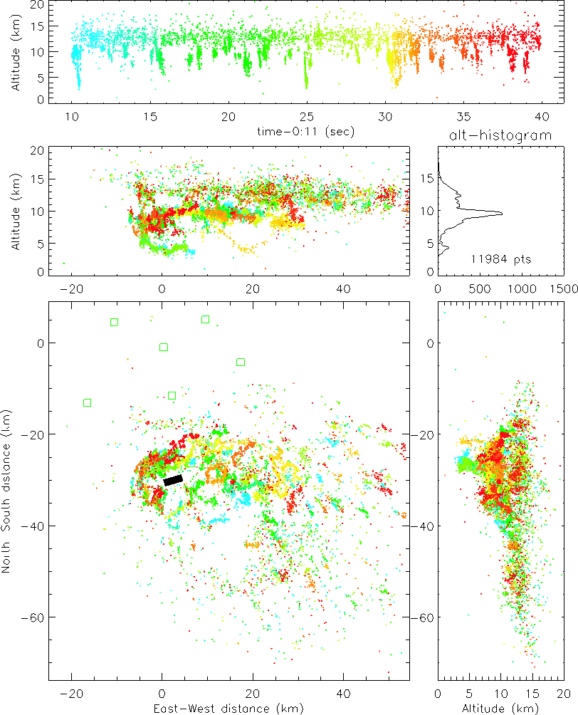
Lightning in a Tornadic Storm
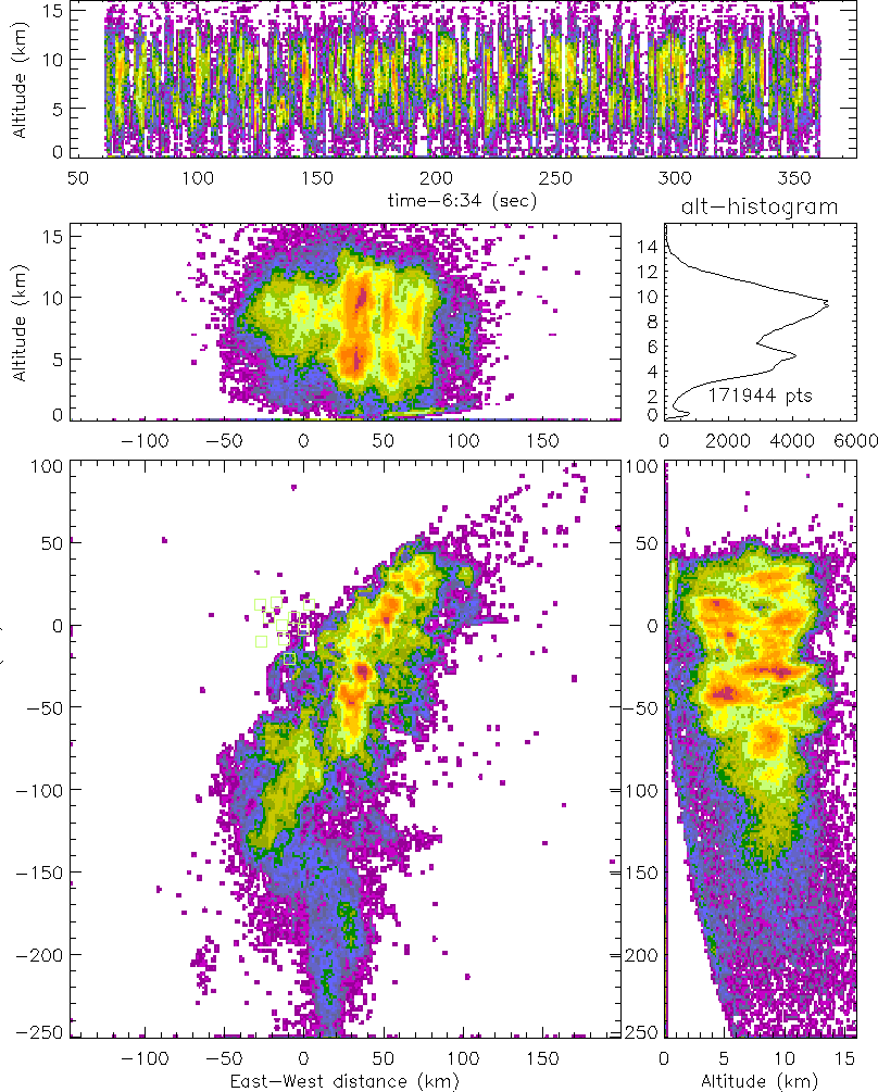
Figure 4 shows lightning in the early stages of a tornadic storm that went
on to produce four F1 and F2 tornadoes
over northern Oklahoma City on the evening of June 13, 1998. Thirty seconds of
lightning activity an hour earlier are shown; this was a few minutes prior
to touchdown of an initial F0 tornado from the storm. The ground track of
the tornado is indicated by the black bar in the figure. Amazingly, the
lightning exhibited a counter-clockwise `hook'-like structure on the west
side of the storm, similar to the hook echoes observed by meteorological
radar in tornadic storms. The hook enclosed a lightning-free region about 5
km in diameter. As before, the lightning hole almost certainly corresponded
to the storm updraft. This is consistent with the fact that hook radar
echoes surround a weak echo region known to be the location of the main
updraft in tornadic storms. The tornado touched down five minutes later,
immediately below where the updraft had been. The storm moved eastward
at about 50 km
![]() ,
which would have placed the tornado in
the low-altitude lightning region (3-4 km) on the west side of the storm.
The lightning in this region was presumably associated with the low-altitude
wall cloud that is a characteristic feature of tornadic storms. Overall, the
lightning consisted of more or less continuous discharges at high altitude in
the storm (11-14 km), punctuated by discrete discharges at lower altitude.
The nature of this activity is not at all understood. Interestingly,
no cloud-to-ground discharges are indicated to have occurred, either in
the mapping observations or by the National Lightning Detection Network.
,
which would have placed the tornado in
the low-altitude lightning region (3-4 km) on the west side of the storm.
The lightning in this region was presumably associated with the low-altitude
wall cloud that is a characteristic feature of tornadic storms. Overall, the
lightning consisted of more or less continuous discharges at high altitude in
the storm (11-14 km), punctuated by discrete discharges at lower altitude.
The nature of this activity is not at all understood. Interestingly,
no cloud-to-ground discharges are indicated to have occurred, either in
the mapping observations or by the National Lightning Detection Network.
Final Comments
Although it is well known even to the casual observer that Great Plains storms are very active electrically, the mapping observations have shown in detail just how active the storms are. The results also show that the total lightning activity can be a useful indicator of the nature and severity of storms. The observations raise a number of questions about the electrification processes that produce the lightning, particularly in severe storms. We plan to operate the mapping system in a multi-investigator study of large hailstorms and supercell storms in northwestern Kansas and northeastern Colorado during the summer of 2000 that should enable us to answer some of the questions. A second generation mapping system will also be operated by NASA scientists in northern Alabama to study the value of space-borne optical lightning detection by geosynchronous satellites. Low-earth orbit optical lightning detectors have already provided fascinating observations of the statistical distribution of lightning over the surface of the earth [Christian and Latham, 1998], and have been shown to be well-correlated with ground based observations [Thomas et al., 1999].
Current work with the mapping system is directed at processing the observations in real time, both for research studies and potential operational applications. Real-time observations are made possible by the use of wireless communications links and internet data connections to bring the time-of-arrival measurements to a remote processing location.
Acknowledgments
This work has been supported by the National Science Foundation under ARI Grant ATM-9601652. Initial development of the lightning mapping system was supported by the U.S. Air Force Office of Scientific Research under grant F49620-96-1-0304.
References
Christian, H.J., and J. Latham, Satellite measurements of global lightning, Q. J. Roy. Meteorol. Soc., 124, 1771-1773, 1998.
Cummins, K.L., M.J. Murphy, E.A. Bardo, W.L. Hiscox, R.B. Pyle, and A.E. Pifer, A combined TOA/MDF technology upgrade of the U.S. National Lightning Detection Network, J. Geophys. Res., 103, 9035-9044, 1998.
Maier, L., C. Lennon, T. Britt, and S. Schaefer, LDAR system performance and analysis, in Proc. Intn'l. Conf. Cloud Phys., Amer. Meteorol. Soc., Boston, Mass., Dallas, Texas, Jan. 1995.
Rison, W., R.J. Thomas, P.R. Krehbiel, T. Hamlin, and J. Harlin, A GPS-based three-dimensional lightning mapping system: Initial observations in central New Mexico, submitted to Geophys. Res. Lett., May, 1999.
Shao, X.M., and P.R. Krehbiel, The spatial and temporal development of intracloud lightning, J. Geophys. Res., 101, 26,641-26,668, 1996.
Thomas, R.J., P.R. Krehbiel, W. Rison, T. Hamlin, D.J. Boccippio, S.J. Goodman and H.J. Christian, Comparison of ground-based 3-dimensional lightning mapping observations with satellite-based LIS observations in Oklahoma, submitted to Geophys. Res. Lett., May, 1999.
Wescott, E.M., D.D. Sentman, M.J. Heavner, D.L. Hampton, D.L. Osborne and O.H. Vaughan, Blue starters: Brief upward discharges from an intense Arkansas thunderstorm, Geophys. Res. Lett., 23, 2153-2156, 1996.