Lightning Mapping Observations during STEPS 2000
New Mexico Tech Lightning Mapping Group
Paul Krehbiel, William Rison, Ronald Thomas
Timothy Hamlin, Jeremiah Harlin, Mark Stanley
Michael Jones, Jarrod Lombardo, Demian Shown
Langmuir Laboratory for Atmospheric Research
Geophysical Research Center
New Mexico Institute of Mining and Technology
Socorro, New Mexico 87801
The New Mexico Tech Lightning Mapping Array (LMA) was operated in the
STEPS project area from mid-May to mid-August, 2000. Thirteen measurement
stations were deployed over a four-county area in northwestern Kansas
and eastern Colorado. The system locates the sources of impulsive VHF
radio signals from the lightning by accurately measuring the time that
the signals arrive at the different receiving stations. Each station
listens for the lightning signals in an unused television channel, in
the case Channel 3 (60-66 MHz). The arrival times are measured with 50 ns
accuracy using a special PC-based digitizer card coupled to a GPS receiver.
The measurements enable us to obtain accurate 3-dimensional pictures of
the lightning inside storms.
Each of the mapping stations was connected to an operations center
in Goodland, Kansas via wireless high-speed communications links. The links
were used to remotely monitor and control the station operation and for
real-time processing of the observations. Shown below is an example of
real-time observations obtained with the system.
Real-Time Lightning Observations on July 3, 2000
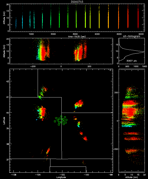
Above is an overview of slightly more than an hour of lightning activity
over the tri-state
Kansas/Colorado/Nebraska area on July 3, 2000. The colors indicate the
time sequence of the data, with red being most recent. The locations of the
measurement stations are indicated by the green squares. The mapping
network located the lightning activity over an area 400-500 kilometers (250-300
miles) in diameter, with the maximum range being limited by the radio
horizon. The lightning is imaged in three dimensions in the vicinity of the
network, gradually decreasing to two dimensions with increasing range.
The increase in the minimum altitude of the sources with distance is due
to the curvature of the earth.
Some Interesting Observations:
![[Go to main LMA page]](images/goback.jpg) Go to the main Lightning Mapping Network page
Go to the main Lightning Mapping Network page
Last Modifications made on Wed Jul 26 22:04:25 MDT 2000